Update
- Added French translation package for the manual (
LittleNavmap-manual-language-package-fr-2.2.zip). Install this to get access to the French legend and online help (Manuel Utilisateur de Little Navmap). Includes the PDF manual. Thanks to Patrick JUNG alias PATBEST for translating the manual!
Note: Updated LittleNavmap-manual-language-package-fr-2.2.zip on Sunday, 16 Dec 11:40 UTC.
Changes from Release 2.0.3 to 2.2.2
For more details on fixed issues look at the included CHANGELOG.txt or here online for a complete list across all versions.
Click on images for large view.
Quick Overview
- Aircraft performance, fuel planning and more.
- Elevation profile now zoomable, displays top of climb and procedure altitude restrictions.
- Display of Airport traffic pattern.
- MORA Grid (minimum off-route altitude grid) shown on map.
- Sun shadow on map.
- Airport weather symbols on the map.
- Modifier mouse clicks in map. E.g.
Ctrl+Clickto start measurement orShift+Clickto place range rings. - Sunrise and sunset for airport in information.
- Bearing and distance to user aircraft in information display for airports and navaids.
- Better printing for map and flight plan.
- Insert flight plan at any position into the current one.
- Change style (also
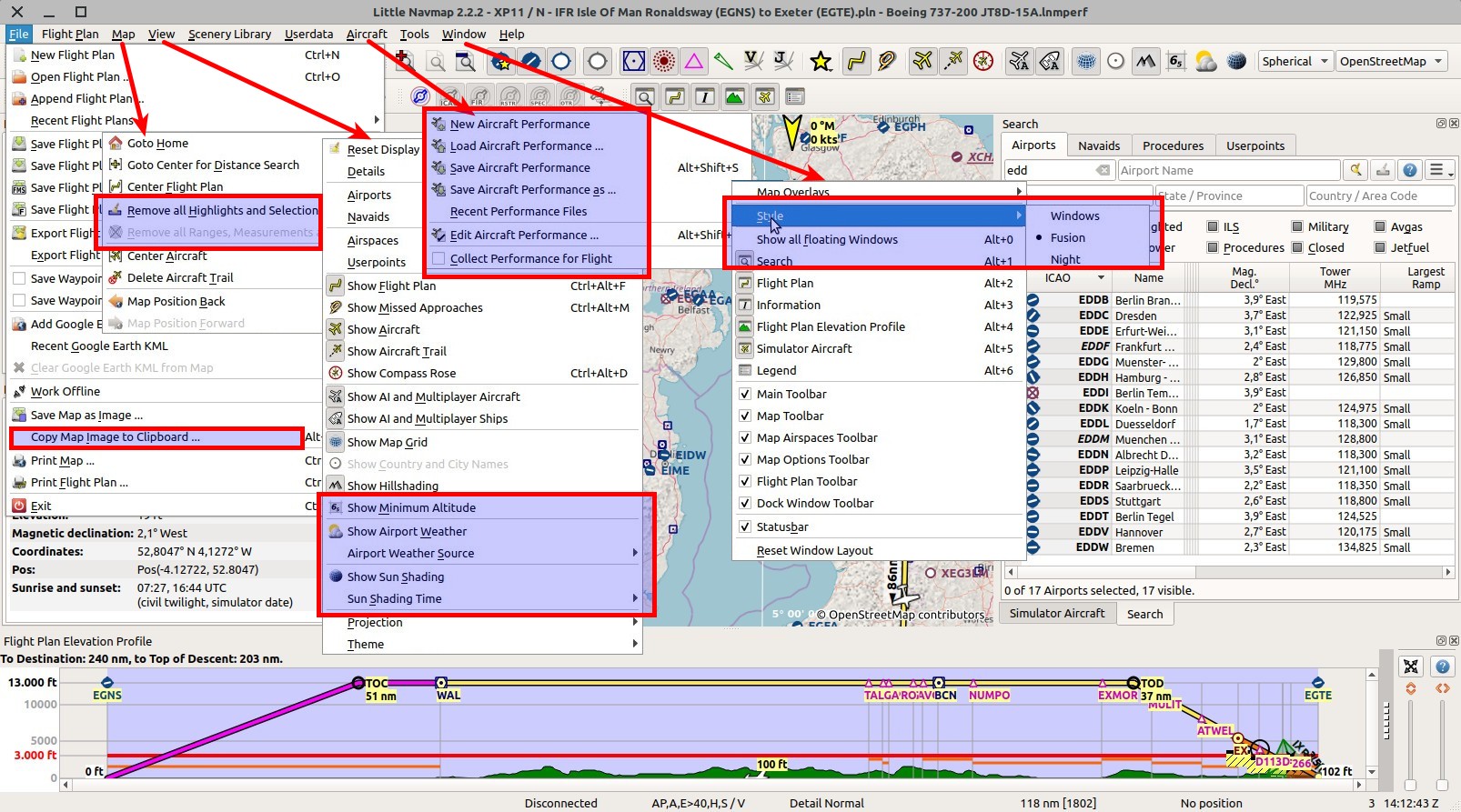
Night) on the fly without restart from the menuWindow. - Copy map image to clipboard.
- Performance issues with X-Plane airports fixed.
- Prepared for Active Sky XP.
New online manual chapters and/or changes
- Major update and enhancements in elevation profile: Profile and Legend.
- Aircraft performance:General,Editing and New Flight Plan Table Columns.
- Airport Weather: General, Menu Items and Legend.
- Sun shading.
- New settings, crab angle and next wayppoint: Compass Rose and Legend.
- Airport traffic pattern: General, New Menu Items and Legend.
- MORA Grid (minimum off-route altitude grid): New Menu Item and Legend.
- Mouse clicks with modifiers in map.
- Switch user interface styles on the fly.
- Options for map display and simulator aircraft: Avoid blurry map and more details for scrolling and zooming while flying.
- X-Plane scenery_packs.ini is used now.
- Scenery loading can now exclude files.
- Improvements to printing.
- New airport related menu items in procedure search.
- Insert flight plan into current plan.
- Sunrise and sunset for airport in information.
- Bearing and distance of user aircraft to airport or navaid in information.
- Show more less data in aircraft progress.
- Better highlighting for airspaces from information window.
New Options
Tooltips in dialog Options give more help.
Note that some options were moved around in the options dialog. These are also marked in the images.
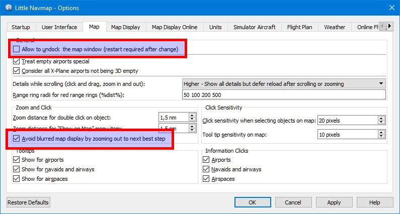
Map
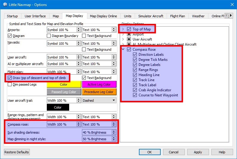
Map Display
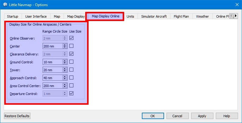
Map Display Online
Flight Plan

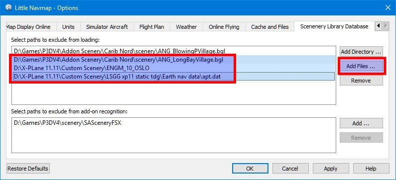
Scenery Library
User Interface
New Features
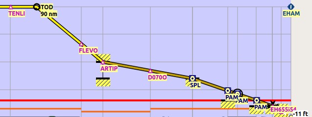
Elevation Profile
- Added scrolling and zooming ability to elevation profile. Elevation profile now has a context menu also including
Show on Mapand more functions.
Added splitter to elevation profile dock window which has sliders for zooming vertically and horizontally. These can be hidden by dragging the splitter to the right.
Zooming can also be done using mouse wheel (Wheel+Shiftfor vertical zooming).
Added keyboard navigation using cursor keys and numpad keys for zooming and scrolling.
Panning in elevation profile with mouse click and moving like in map. Double click zooms to position on map. #34 - Elevation profile now uses same aircraft icon as map. Changed elevation profile to completely adhere to map painting settings like line width, text size and symbol size. Profile display now hides flight plan if hidden on map. #298
- Adjusted elevation profile to display passed, active, straight-in and circle-to-land flight plan legs in the same colors like the flight plan on the map. Navaid symbols are now shown on the descending or ascending line. #298
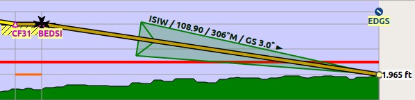
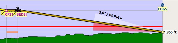
- Added option to display ILS and VASI slopes in elevation profile if an approach is selected. Menu items allow to disable these. #299
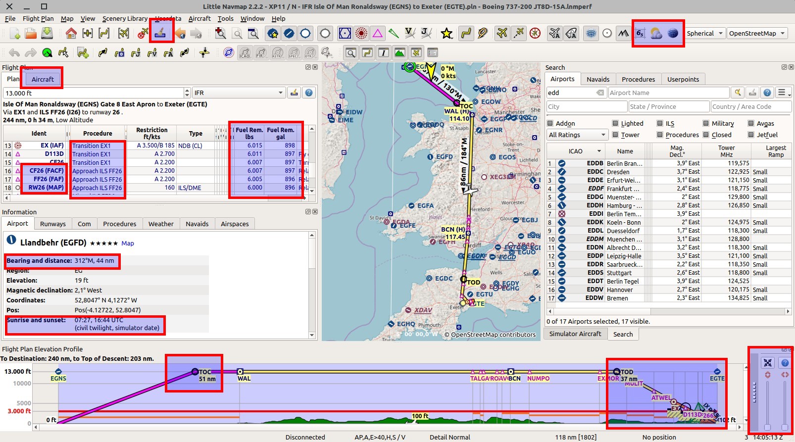
- Added calculation and display for top of climb to elevation profile display. Calculation based on aircraft performance data.
- Now showing procedure altitude restrictions in profile display.
- Top of descent is calculated considering altitude restrictions of approach or STAR. Same for top of climb and SID. All legs after and at the FAF and FACF points are forced to minimum altitude to avoid arriving above ILS glideslope.
- Display of
Above Ground Altitudeon top label in profile window follows climb and descent slope instead of using cruise altitude. - Giving clear error indication if cruise altitude is too high (i.e. TOC and TOC overlap) or if restrictions are violated due to too low cruise altitude.
- Removed barely visible highlight on map when hovering cursor above elevation profile. Highlight colors can now be customized in
little_navmap_mapstyle.ini. Mouse position in elevation profile is now shown with a cyan/black circle on the map. #34 - Jump back to aircraft functionality added in elevation profile. Uses the same settings as the map. #34
- Fixed display color of profile labels for night mode. Removed all dark profile colors and pens from
little_navmap_mapstyle.ini. Using OS and style colors now. #34 - Solved problems where aircraft in elevation profile jumped to wrong leg or moved backwards.
- Aircraft track is now ignored when determining profile window altitude to avoid confusion when stale tracks result in wrong profile maximum.
- Aircraft direction now turned if reversal relative to active leg detected.
- Fixed several issues with aircraft movement and trail in elevation profile. Profile trail now depends on active leg and is now saved separately from aircraft trail on map.
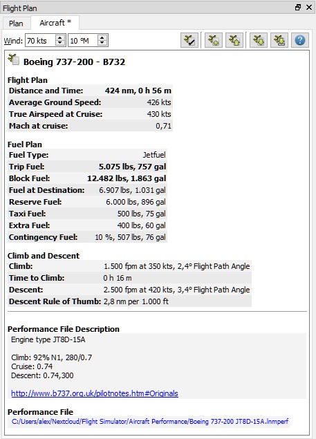
Aircraft Performance
See main menu -> Aircraft and tab Aircraft in dock window Flight plan.
Note that the new tab in the Flight plan dock window is meant for fuel planning and does not change during flight (except when collecting performance data).
- Added aircraft performance facilities including edit dialog, new, save, save as, load, file history and report.
Performance files (lnmperf) can be dragged into the main window of Little Navmap to load.
Added main menuAircraftand tab on flight plan dock window for loading, saving and editing of performance files. - Performance and fuel calculation can use an average cruise wind setting where wind is interpolated for climb and descent for calculation.
- Added automatic aircraft performance calculation option during flight (
Aircraft->Collect Performance for Flight). - A default performance profile with 3 NM / 1000 ft descent and climb rules and no fuel consumption is default.
- Flight plan table shows both fuel weight and volume in separate columns.
- Window title now shows aircraft performance file name additionally to flight plan file and change state indicated by
*. - URLs are recognized in aircraft performance description and can be opened there. Local file and directory links (e.g.
file:///C:/Projekte/atoolsorfile:///home/alex/) as well as web URLs are recognized and opened. - Showing red error messages on top of fuel report indicating invalid or missing values.
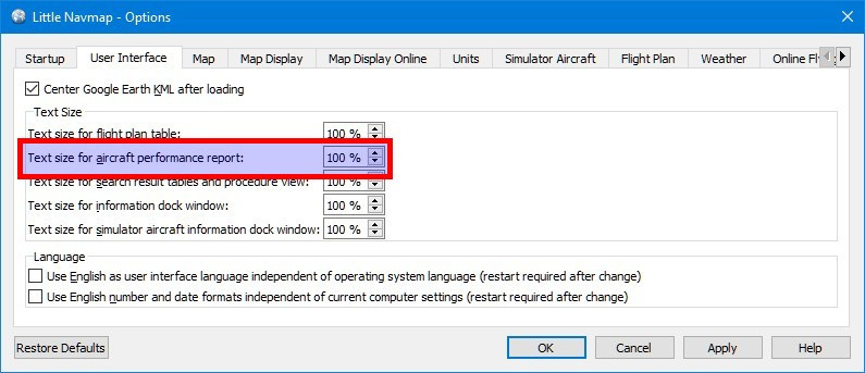
- Added setting in options to change text size in performance report.
- Added aircraft performance file to userpoint log entry.
- Removed now useless speed setting from flight plan dock and deleted rule of thumb descent setting in options dialog.
Printing
See main menu -> File -> Print Map and Print Flight Plan.
- Added flight plan column selection to print dialog. Added more options for header, fuel, performance and others to print dialog.
- Improved printing of flight plan table. Now has proper word wrap, proper column sizes and shows a header for each page.
- Now uses printer resolution for printing the map to get sharper images. This does not apply to the map background.
- Added colors for procedures to printed flight plan table as shown in flight plan dock window.
Online Networks
- Added settings for online center sizes in options dialog. Previous settings from INI file are now ignored. See dialog
Optionson tabMap Display Online. #267 - Added estimated arrival time to online client information tab and search table. Invalid times are now omitted in display. #303
- Changed lower limit of online updates for custom networks to five seconds. Emphasized warning to not to use this for official networks. See dialog
Optionson tabOnline Flying. - Fixed wrong heading display for online aircraft in information display in some cases.
- Improved check for valid whazzup file in options dialog. Now looking for sections
!GENERALand!CLIENTS.
Compass Rose
- Now showing crab angle and added display indicator for next waypoint in compass rose. #284
- Added configuration options for compass rose in tree view in dialog
Optionson tabMap Display. #285 - Text size for compass rose, measurement lines and range rings can now be set in dialog
Optionson tabMap Display. - Compass rose range rings are now always drawn. Also if not connected to simulator.
- Fixed error in compass rose where decimal digits were truncated in some cases.
Flight Plan
- Added drag and drop of flight plans from file manager into main window for loading. Accepts a single flight plan file and all allowed formats for loading (
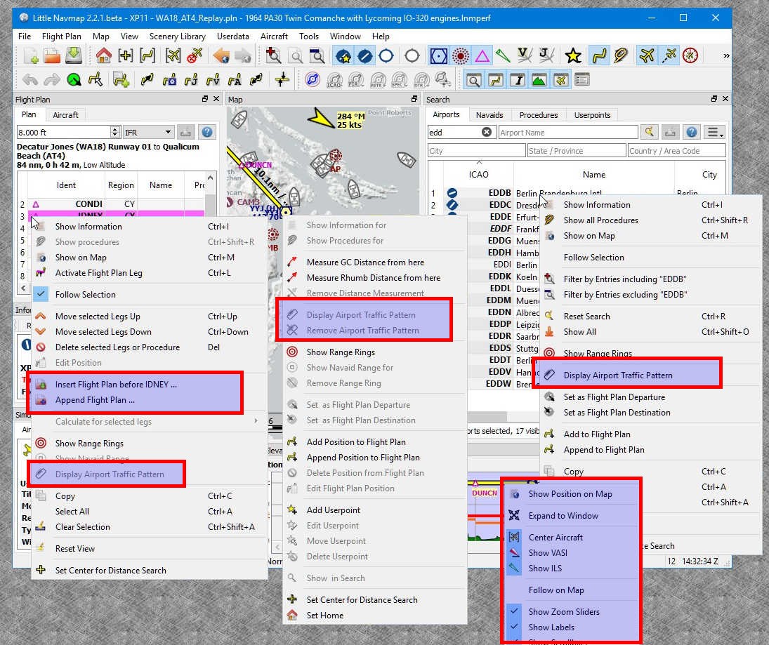
fms,flp,pln) as well as aircraft performance files (lnmperf). #291 - Added
Insert Flight Planmenu item into flight plan table context menu. AddedAppend Flight Planmenu item into flight plan table context menu. - Now selecting and highlighting imported legs after inserting or appending flight plan. #264
- Now displaying FAF, IAF, FACF and MAP in the procedure preview, flight plan table and tooltips. #196
- FAF and/or FACF is shown with a Maltese cross on the map and in elevation profile. The Maltese cross is applied to either final approach fix or final approach course fix depending on ILS GS intercept altitude and approach type. #196
- Changed last
Proceed to Runwayleg to correctCircle to Landfor approaches without runway ends andStraight Infor others. - Circle-to-land and straight-in legs following a missed approach point are now drawn correctly with a dashed line on the map and in the flight plan profile. #252
- Added indication for DME distance to or from waypoint in procedure search (e.g.
TAU+6) and flight plan table for certain leg types.
This minimizes the confusing duplicate display of idents in the flight plan table. #265 - Added procedure name to flight plan table instead of the generic names like
SIDorSTAR. - Added display of ARINC name (e.g.
Q21orI16) to flight plan header label since some FMCs need this value.
#306 - Added warning dialog for flight plan zero cruise altitude before saving. #263
- Made loading of procedures more tolerant for renamed runways and for ARINC names of procedures.
- Removed annoying change in flight plan when Little Navmap adapted start position on loading. Now leaving flight plan change status unchanged.
- Disabled export of approach procedures for Flight Factor airbus since required data is unknown.
- Fixed issue with missing runway in X-Plane FMS files having circle-to-land approaches. X-Plane can now load these type of approaches without error message.
- Fixed issue for FSX/P3D flight plans missing byte order mark. These were not accepted by ASN or ASX.
- Added saving of altitudes for X-Plane FMS formats which will show up for each waypoint in the stock FMS now.
- Fixed issue in route description generator which omitted SID and STAR when no intermediate waypoints were present.
- Flight plan table now displays localizer frequencies for approaches.
- Moved FMS 3 format to export sub-menu since it became less important.
Procedures
- Now loading procedures partially from a flight plan if some could not be found.
- Better error report on procedure loading issues. Now showing the procedure names which cannot be found in the database.
- Fixed several drawing and other issues with procedures.
- Added workaround for 3-letter airport idents in procedures which were not recognized and showed an error in the procedure search (red procedure leg).
Map

- Added mouse click and modifier options for quick access. Doing a second click on the hot spot of a shown feature like range rings or measurement lines removes it. #268
- Shift+Click: Add or remove range rings or navaid range ring.
- Ctrl+Click: Start rhumb-line measurement or delete measurement line.
- Alt+Click: Start great circle line measurement or delete measurement line.
- Ctrl+Shift+Click: Add or edit userpoint.
- Ctrl+Alt+Click: Insert point into nearest flight plan leg.
- Shift+Alt+Click: Append point to flight plan.
- Added
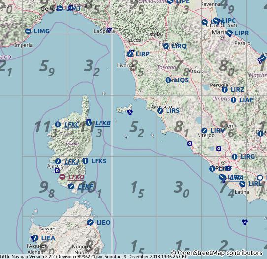
Shift+Wheeland key combinations for zooming in small steps. See legend for a list of keys. - Added minimum off route altitude (MORA) data one degree grid display to map. Data coming from Navigraph (also from the included database cycle 1801). See main menu ->
View->Show Minimum Altitude. #84 - Added extra airport display layer in map that shows runways and runway numbers before airport diagram shows up. #308
- Fixed several problems for aircraft and next waypoint centering mode. Updates are now triggered by a timer depending on speed and distance to waypoint. Minimum zoom distance is now a function of altitude above ground.
See dialogOptionson tabSimulator Aircraft:Allow scrolling ...andJump back .... - Centering of active flight plan leg and aircraft (if enabled in options) falls back to simple aircraft centering if distance to flight plan is larger than 50 NM.
This helps to avoid situations where the program zoomed too far out when flying with stale flight plans. - Changed jump-back-to-aircraft logic to avoid weird behavior (zooming far out and other issues).
When aircraft is on ground orCenter map on aircraft and next flight plan waypointis not selected:- Start looking around on the map by moving first (mouse drag or cursor keys) and not by zooming (mouse wheel or plus and minus keys) to suppress aircraft centering for a while.
- Zooming without movement (drag or cursor keys only) keeps the zoom distance.
- Added option to avoid blurred online maps. This is enabled per default. See dialog
Optionson tabMap:Avoid blurred .... This options works best with the map projectionMercator. #254 - Added option for sun shading on map which can use real time, simulator time or user defined time. See main menu
View->Show Sun ShadingandSun Shadingsub-menu.
Shading darkness can be adjusted in dialogOptionson tabMap Display:Sun shading .... - Added dialog to set user defined time and date for sun shading. See main menu
View->Sun Shading->Set user defined time. #60 - Drawing of complex X-Plane airports accelerated significantly. #245
- Added dashed center line to ILS feathers and made feathers semi-transparent.
- ILS labels now adhere to the text background color setting for navaids. This allows to select a white background for the labels for better visibility.
- Now omitting curves, arcs, holds, procedure turns and other fancy geometry of procedures on high zoom factors to avoid a mess up of graphics in the spherical projection. Fixed flight plan leg distance label turning into weird directions when using spherical projection and at high zoom factors. #287
- Aircraft icon heading is now more correct at higher zoom levels when using spherical projection. #239
- Improved zooming when using a touchpad. Now less sensitive when using two finger touchpad or other gestures.
- Added workaround for issues when zooming to map objects. Now determining the best zoom distance until all is visible.
- Fixed issue of map jumping to the wrong place when zooming around the anti-meridian with the mouse wheel.
- Changed map context menu to correctly show only the mentioned item in
Show informationmenu item and nothing else. - Replaced home view symbol on map with actual icon from toolbar button.
- Moved
Remove all Ranges, Measurements and Patternsfrom all context menus to main menuMap. - Several issues with the map context menu and
Show Information fixed. - Fixed several drawing issues with the aircraft trail, procedures on high zoom levels, flight plan, ILS and others.
- Replaced OpenMapSurfer hillshading with the one used for OpenStreetMap since server is offline.
Airport Weather
See main menu -> View -> Show Airport Weather and
Airport Weather Source. #6
- Added display for weather symbols to map showing lowest cloud coverage (from empty to filled circle), wind direction, wind speed (barbs) and flight rules according to official color coding: LIFR/magenta, IFR/red, MVFR/blue and VFR/green.
- Added map weather selection for all supported weather sources in menu view. See main menu ->
View->Airport Weather Source. - Airport weather icons are loaded from FSX/P3D and remote connections too.
- Showing flight rules and icons for all sources in information and tooltip. Showing selected source for weather in map in the information display by adding suffix
- MaptoFlight Rulestext.
Weather
- Attempt to fix weather loading issues (disappearing report) for X-Plane
METAR.rwx. Weather data is now kept if file was deleted. - Fixed issue with ActiveSky showing old weather from stale
activeflightplanwx.txtflight plan files. Now always using the latest from eitheractiveflightplanwx.txtorcurrent_wx_snapshot.txt. - General improvements to improve reliability when reading weather files and detecting changes on them.
- More improvements on error tolerance and fixes when reading METARs.
- Prepared for Active Sky XP.
Information and Progress
- Added sunrise and sunset display (civil twilight) in UTC for airport information display. Time is based on simulator date or real date depending on connection status. See in dock window
Informationon tabAirport. #281 - Added distance and bearing (rhumb line) to navaids and airports from the user aircraft in information window and tooltip. Disabled when distance is larger than 500 NM. #274
- Added
More/Lesslink to aircraft progress display to show detailed or brief performance information during flight. - Added crab angle to aircraft progress display to indicate the needed heading to the next flight plan waypoint in cross wind. #284
- Information tabs for airspaces and online centers now highlight geometry on map when clicking the blue
Maplink in the information window.
Above mentioned tabs also have aRemove Highlights from Maplink on top that clears all highlighted airspaces from the map. - Now showing restricted airspace designation (like
D-30) in information and tooltip. - Showing active time criteria (NOTAM, holidays or others) for airspaces in information window. Added multiple code as indicator for duplicate overlapping airspaces. Navigraph data only. #279
- Now displaying related airport information for navaids if available. #289
- Com frequencies are now forced into 25 kHz raster on display to avoid invalid frequencies like 0.69 MHz.
- Showing more important flight parameters (IAS, indicated altitude, etc.) bold in aircraft progress.
- More fixes and improvements to information display and tooltips.
Airport Traffic Pattern
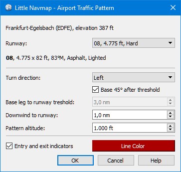

- Added option to draw airport traffic pattern on the map to all map, flight plan table and airport search context menus.
Display Airport Traffic pattern at ...is enabled when right clicking on an airport.
Right click on traffic patter hotspot near runway threshold to remove it. - A configuration dialog is shown when adding a traffic pattern that allows to customize distances, colors and other options.
Options
- Moved options
Use a short name ICAO_ICAO.pln when saving FSX or P3D flight plans instead of the long name,Avoid overwriting Flight Plan with not matching departure and destinationandCenter flight plan on map after loadingto flight plan tab in options. - Various other changes for online networks, map display, scenery library and more. See related items in this change log.
Search
- Added
Show Information for Airport,Show Airport on MapandShow Airport in Searchitems to the context menu in the procedure search tab. - Various other improvements and fixes to procedure search.
Userpoints
- URLs are now recognized in userpoint information display and can be opened there. Local file and directory links (e.g.
file:///C:/Projekte/atoolsorfile:///home/alex/) links as well as web URLs are recognized and opened. - Fixed issue where takeoff or landing airports and runways were not recognized correctly for logbook entries.
User Interface and General
- GUI style including
Nightcan now be changed on the fly from the menuWindow->Style. Removed style from options dialog and moved map darkness for night style to dialogOptionsto tabMap Display. Fixed all remaining artifacts which appeared after style change. #142 - Added option to disable map window undocking in options dialog on tab
Map.
Allowing to undock the map window (option checked - default) can cause issues when resizing dock windows or the main window.
Uncheck this option if you see strange or annoying resizing behavior when changing dock window or main window sizes.
In some cases the dock window might also freeze, i.e. docks cannot be resized. Uncheck this option if you see one of these issues. Reset window layoutnow also changes window size and centers window to avoid messed up layouts. Changed default layout to avoid locked elevation profile size.- Disabled restoring of full screen mode on macOS since Qt freezes dock windows.
If that happens double click the title bar of any dock window to float it. Double click again to dock it back and you can resize all docks again. - Now always showing version in main window title. Development versions also show Git revision. #304
- Added
Copy Map Image to Clipboardfunction in file menu. - Now appending date and time suffix to map screenshot name to avoid overwriting for
Save Map as Image. - Added warning dialog when using the buggy and limited online elevation data.
- Added information dialog for Navigraph only scenery mode. #262
- Changed
Show map windowmenu item toShow all floating Windowswhich raises all floating dock windows. Can also be used to get a lost map window back. - Now raising all floating windows on startup to avoid hidden and/or inaccessible windows.
- Changed search path for custom map themes to be based on executable path since macOS gives a wrong current directory. #261
- Log file is now rotated if the file size of 10 MB is exceeded. This avoids overwriting on startup and eases error reporting. #275
- Added new
Remove all Highlights and Selectionsmenu item to menuMapand toolbar. #308 - Added
Copy to Clipboardto update notification dialog to copy contents as plain and formatted text. - Added FAQ link help menu.
- Various other improvements regarding error messages and changes in menu structure.
Scenery Library
- Files can now be excluded from loading for all simulators in options dialog. #29
- List in exclusion paths now allow multi selection. See dialog
Optionson tabScenery Library Database:Add Files .... - Check box for reading inactive scenery is now enabled for X-Plane to choose between reading
scenery_packs.inior full directory structure in scenery loading dialog. This helps if using tools to disable scenery. #151 - Now fetching the first X-Plane installation path from
x-plane_install_11.txtas base path. - X-Plane parking positions are now at correct coordinates. #256
- Fixed issues with symbolic links in scenery loader. Now using path as-is instead of converting to canonical path (i.e. resolving the symbolic links). #29
- Database minor version updated to 13.
X-Plane / Little Xpconnect
- Now reading X-Plane
acffiles once to get aircraft name and engine type for a better classification. Allows to show helicopter and jet AI symbols in Little Navmap. #271 - Added airplane model and registration. Now using description for title.
See the included CHANGELOG.txt or here online for a complete list across all versions.
All files are checked by VirusTotal.