Notes
- It is recommended to reload the scenery library.
- X-Plane users: Reinstall the included Little Xpconnect 1.0.9 for bug fixes regarding magnetic variation.
- Translations for the graphical user interface are included with the download.
Translation packages are not required.
Changes from Release 1.8.5 to 2.0.2
Quick Overview
- Several user interface translations included.
- Support for online networks like VATSIM or custom networks.
- User defined waypoints: Complete management, import, export, search and display.
- More flight plan export formats.
- Added menu options to save waypoints instead of SID/STAR or approaches.
- New airport display options.
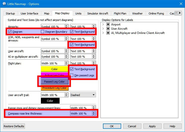
- Compass Rose
- IVAO weather and nearest NOAA weather.
- Included Navigraph AIRAC database was updated to cycle 1801.
New online manual chapters and/or changes
- Userpoints
- Userdata menu
- Userpoint map context menu items
- Online Networks
- Compass Rose
- Edit flight plan positions
- Coordinate formats
- Customize display radius for online centers
- Customize userpoint icons
New Options
Click on image for large view. Tooltips in dialog Options give more help.

Translations
- Github Issue: #135
- Program user interface translations: Dutch, Brazilian Portuguese, French, Spanish and German. All complete.
No language packages needed. Thanks to all who contributed! - Included map legend in Spanish, French and German.
- Help system now more flexible and can load legend and help files if present for language.
Also uses a fuzzy way to find files by ignoring language region/country
likept(Portuguese) vs.pt_BR(Brazilian Portuguese). - French offline PDF manual is from previous version. Full translation will be provided as an update package.
Thanks to Daniel "Wolf", Eddy Crequie, merspieler, Patrick JUNG , Ricardo Vitor and Stephan Leukert for the translations.
Online Networks
- Github Issue: #45
- Manual: Online Networks
- Added IVAO, VATSIM and custom online networks. IVAO is currently disabled due to missing clearance.
Need volunteers to run a mirror. - All online network tabs and menu items are hidden in Little Navmap until online is activated in
dialogOptionson tabOnline Flying. - Update rate and URL configuration for custom networks in dialog
Optionson tabOnline Flying. - Display of clients, servers and online centers on map, in information windows, search tabs and context menus.
- Search highlights and tooltips for centers and client aircraft similar to airports and navaids.
- CSV export via clipboard for all online information in search window.
Userpoints
User defined waypoints like visual reporting points, bookmarks, points of interest and others.
- Github Issue: #3
- Manual: Userpoints
- New main menu
Userdatawhich provides various import and export options and more. - A new search tab
Userpointsin theSearch Windowfor editing and searching with the same functionality
as the other search tabs. - New menu entries in map context menu to add, edit, delete or move userpoints.
- Information window and map tooltips can display userpoint information on tab
Navaids. - Edit dialog for userpoints also allows bulk edits on more than one selected point.
- Add userpoint dialog remembers input to ease adding more than one similar point.
Content can be cleared using the reset button. - Add dialog is context sensitive and prefills airport data if you add a bookmark on an airport for example.
- Add userpoint from map is filled with actual elevation at clicked position (only for GLOBE data).
- Coordinates can be edited manually in edit/add dialog. More than 10 coordinate formats are recognized. See tooltip on
Latitude and Longitudefield. - Userpoints can be added to a flight plan and are converted to flight plan user defined waypoints (green square).
- A timestamp of last change is kept for each userpoint which allows to find latest changes or imports.
- Userpoints can be temporary. These will be removed on startup.
- Flight plan drag and drop editing allows to add userpoints.
- Import and export for CSV (format from other well known programs), Garmin
user.wptand X-Planeuser_fix.dat. - Export to a XML file suitable for the FSX/P3D BGL compiler.
- Icons and types can be extended by placing SVG files with names like
userdata_My own Userpoint Type.svgin
the settings directory. Icons for stock types can be changed by placing an icon with the same name like
userdata_Airstrip.svgin the settings directory. See customization below. - Option for automatic creation of userpoint entry of type
Logbookfor each takeoff and landing.
Logbook entry for landing contains trip information like average speed, fuel consumption and more. - Made naming in GUI more consistent.
Userpointsare bookmarks, VRPs, etc.,
Positionsare user defined positions in a flight plan. - Creating backups of file
little_navmap_userdata.sqliteon startup since undo/redo is not available yet.
Flight Plan Save and Export
- Added menu options to save waypoints instead of SID/STAR or approaches. This affects all flight plan formats.
Note that procedure information is omitted in the flight plans if enabled and cannot be reloaded.
#195
See Save Waypoints for Approaches and Save Waypoints for SID and STAR
in the manual. - New flight plan export formats: Blackbox Simulations Airbus, iFly 737, ProSim, UFMC and X-FMC.
- Added
Show in SkyVectorto export menu. - Can now load FSC flight plan files. Does not load procedures.
- Save button is now always enabled to allow saving PLN file again after P3D changes file on loading.
- Added option to save FSX/P3D flight plans using short names.
Optionson tabFlight Plan. - Export clean PLN flight plan file now remembers its own directory to allow saving to separate folder.
- Fixed issues where circle-to-land procedures were not loaded properly and were incorrectly assigned to a runway.
- Fixed issue where STAR procedures with runway assignment were not loaded correctly.
- Fixed issues in
corte.inexport for flight factor aircraft. LastDCTis now omitted on export and full names
are used for approach ident (I16Lbefore, nowILS16L). - Fixed issue where flight plan was saved in the wrong format after undo/redo and
Save as. This resulted in e.g. FSX PLN content in a FMS file. - Fixed issue when loading Fsbuild created flight plans which are missing the altitude field.
Flight Plan
- Coordinates of flight plan user defined waypoints can now be changed in edit dialog.
See Edit Flight Plan Position. - Now highlighting flight plan segments traveling wrongly against one-way airways in red to indicate error.
- Showing ILS frequency in flight plan table if an ILS or LOC approach procedure is used.
- Added follow selection mode to context menus of the flight plan window.
This will center selected navaids or airports on the map using the current zoomlevel when
enabled. #129 - Added
zoom to departureoption in parking question dialog which shows up before saving. This allows to quickly
assign a parking position on the map. - Fixed display issues around procedure names and suffixes.
- Now showing navaid ranges for navaids which are parts of procedures E.g.
Show navaid rangefor a
NDB which is part of a procedure.
Flight Plan Description
- Fixed errors in flight plan description parser. Now nearest airport or navaid is used for non
unique names instead of giving preference to (possibly far away) waypoints.
#213 - Fixed several issues when parsing route strings. Now takes nearest navaid only if no
waypoint/airway combination was found. - Fixed misleading warning in route string parser if airport name as intermediate destination or waypoint.
is equal to an airway.
GUI
- Added zulu time and day of month to status bar on the right (real time and date - not simulator time and date).
- Added display of magnetic declination below cursor to status bar.
- Split Map menu into Map and View since it got too big.
- Added tooltips for all tab headers in main window and shortened some tab names to save space.
- Removed menu items from macOS application menu since automatic adaption from Qt does not work.
Fixes for missing about dialog on macOS.
Flying
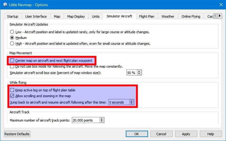
- Added option to keep active leg on top of flight plan table while flying.
Optionson tabSimulator Aircraft. - Added new flight plan and aircraft centering mode which keeps active leg and aircraft
visible on the map when flying. Falls back to center aircraft on ground.Optionson tabSimulator Aircraft.
#133 - Added
jump back to aircraftoptions after given time when flying. DialogOptionson tabSimulator Aircraft.
Allows zooming and scrolling during flight without disabling and re-enablingCenter Aircraft.
#133 - Added option to dim passed legs of flight plan on the map and display them in a different
color. Labels for passed legs are omitted to unclutter the map. Added color selection for passed
flight plan legs.Optionson tabMap Display. All #218 - Adjusted label display for nearest five AI to show within 20 nm if vertical difference is not more than 5000 ft.
- On-ground indication was unreliable for X-Plane causing first leg already centered on ground.
#133
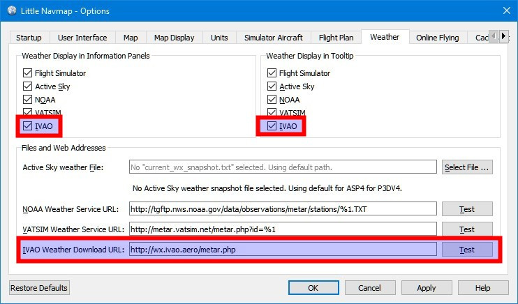
Weather
- Added display for NOAA nearest weather stations. Now downloading index page from NOAA to avoid empty requests.
- Added IVAO weather reports including options, URL configuration, URL test and display of nearest station.
#132 - Weather reports older than six hours are now shown in red in information window on tab
Weather. - Fixed error on METAR stations improperly reporting
CAVOK 9999. - Weather report now corrects old dates back to last valid date instead of showing future dates.
- Variable winds are now reported correctly when speed is missing. #212
- Now reporting variable winds together with wind/direction if both are given. #212
- Fixed report on clouds when altitude was not given. #212
- Fixed variable wind reported incorrectly for
///KTMETAR. #224 - Solved problem with X-Plane METAR.rwx containing duplicate records. #212
- Removed METAR date for simulator weather since it was wrongly parsed and corresponds to simulator date anyway.
Compass Rose
- Github Issue: #141
- Manual: Compass Rose
- Added compass rose showing magnetic direction plus option for line thickness
(Optionson tabMap Display). Compass rose is always visible when enabled.
Heading and track lines are displayed as well if an aircraft is shown. Size is adjusted to screen
with a maximum of 500 nm radius. Enable in menuView->Show compass rose.
Map
- Now falling back to magnetic heading for aircraft rotation on map if true heading is not available.
This should solve wrong aircraft heading on some online network clients where all client aircraft were shown
with a heading of zero degree. - Added X-Plane 3D airport flag as additional criteria for treating empty airports. This can
be used to hide or dim all X-Plane airports which are not 3D. SeeOptionson tabMap. - White airport background can be disabled now.
Optionson tabMap Display. - Added option to disable all airport diagram features except runways for all who like to use
the OpenStreetMap or other map background. See dialogOptionson tabMap Display. - Added options to disable label background color for airport, flight plan and navaids.
Optionson tabMap Display. - Added options to disable map clicks for airports, navaids and airspaces similar to
tooltips. DialogOptionson tabMap. - Fixed map overlays reappearing randomly when switching map theme.
Map Themes
- Changed OpenStreetMap, OpenMapSurfer and Hillshading map downloads to use a SSL encrypted connections (HTTPS).
- Fixed SSL loading problems on Linux (first noticed on Ubuntu 18.04) which kept the program from checking for updates or loading certain map themes like the OpenTopoMap.
Search
- Added override mode for airport ICAO search. All other search options will be ignored if a
user enters more than two characters in theICAO Codefield. Override is indicated in
the bottom label below the search result table. This helps to quickly find an airport without
resetting search options. - Added follow selection mode to context menus of all search windows.
Will center selected navaid, airport or procedures on the map using the current zoomlevel when
enabled. #129 - Increased maximum search radius for airports to 8000 nm.
Information
- Added zero fuel weight and total payload to window
Simulator Aircrafton tabAircraft. - Added estimated fuel at destination and TOD was well as estimated gross weight at
destination to windowSimulator Aircrafton tabProgress. - Now showing transition altitude in airport information if available in Navigraph database.
Procedures
- Changes for SID and STAR that use multiple or parallel runway assignments indicated by e.g.
Allor23L/23R. Added sub menu in procedure search for SID/STAR selection
if more than one runway can be selected. Procedures are now correctly resolved if loading or
assigning such cases. This solves problems when saving procedures in X-Plane FMC 11 format or other
various formats. #179 - Changed context menu
Show Proceduresto show different texts when airport is
destination or departure of current flight plan. Show procedures now sets filter to departure or
arrival procedures depending on selected airport of flight plan. - Now showing a red warning message on top of the flight plan window if STAR and approach
runways do not match. #179 - Fixed tooltip and information display showing facility
Proceduresfor all airports. - Fixed problem where fixes for long (> 200 NM) SID or STAR procedures could not be resolved
and showed red waypoint errors in the procedure search tree. - Duplicate approach procedures for circle-to-land approaches are now suppressed.
Scenery Database
Navigraph
- The included Navigraph AIRAC database was updated to cycle 1801.
- Wrong magnetic declination for VOR stations now fixed.
- Procedures of three letter airports are now recognized (if airport ident did not change).
- Added transition altitude to airports.
- Now updating magnetic declination for VOR, DME or TACAN with a calculated value where missing.
- Corrected wrong runway heading for Navigraph compilation. #214
- Fixes for missing airway segments in DFD compiler. Fixed duplicate removal of
waypoints. #201 - Now ignoring artificial circle-to-land approaches in DFD compiler.
X-Plane and Navigraph
- SID and STAR common routes are now merged correctly into
procedures. This results in correct SID/STAR and also removes
theghostentries. #193 - Now removing all unneeded dummy NDB and VOR waypoints that were
created for airway generation. #201 - Fixed issue where approach name and/or suffix were not read correctly in X-Plane and DFD compiler.
FSX/P3D
- Now reading FSX/P3D scenery entries pointing to
sceneryinstead
of the base directory which is allowed in P3D. These were silently omitted previously. - Reading
.../Roaming/.../add-on.cfgand
.../ProgramData/.../add-on.cfgnow. #211 - FSX/P3D is now hidden in the scenery library menu if the simulator base folder from the registry does not exist. This should help to avoid menu items for uninstalled simulators.
- Added script by Gérard to clean out fake runways for AI in FSX/P3D.
- Added logging for airport altitude to log file when reading delete records from FSX/P3D.
Example:Add-on airport altitude for VQ10 changed from 7703 ft (BGL Scenery/0902/APX72220.bgl) to 8363 ft - Improved BGL file and scenery reading to include hidden and system files.
X-Plane
- Updated included magnetic declination file to 2018.
- Fixed issue with X-Plane airports that have a far off reference position. Now
falling back to center of bounding rectangle or center of a single runway. - Fixed problem where CIFP files with lower case names were not recognized correctly.
- Fixed issues with file or directory exclusion for X-Plane scenery loader
which did not work properly in some cases. Custom Scenery/Global Airports/Earth nav data/earth_nav.datis
now read properly to get fixed ILS. This solves problems wrong ILS heading in many places like LOWI.
Customization
- Program will create a backup of
little_navmap_mapstyle.iniand replace file with new colors
(blue airways). All customization files are now versioned. Section[Options]. - Added
customizefolder and icons.zip for icon templates to allow users creating their own icons
based on default ones.